 BBC
BBCWildfires are raging in several areas of Los Angeles, with high winds and extremely dry conditions fuelling their progress across thousands of acres of land.
Firefighters are so far unable to contain them, with one fire official telling the BBC on Thursday that they were still rapidly expanding.
The largest blaze, in the Pacific Palisades area where many celebrities live, is the most destructive fire in the history of Los Angeles. More than 1,000 buildings have been destroyed.
It's a rapidly changing situation - these maps and pictures chart how the fires have spread, where they are located and what they look like from space.
More fires broke out on Wednesday, including in the Hollywood Hills area, overlooking Hollywood.
Many of the roads near the fire were blanketed with thick smoke and Hollywood Boulevard, home to the Hollywood Walk of Fame, was gridlocked with traffic as people tried to leave.
Firefighters are tackling five blazes
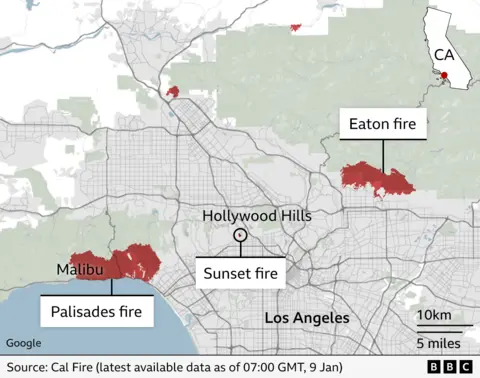
Five fires are burning in the Los Angeles area:
Palisades fire: The largest active fire is burning between Santa Monica and Malibu. Burnt area: more than 20,000 acres. More than 5,300 structures destroyed. At least 30,000 people evacuated.Eaton fire: Second largest fire burning north of Pasadena. Burnt area: at least 13,690 acres. Potentially more than 4,000 structures damaged or destroyed. Five deaths reported.Hurst fire: To the north east of the city. Burnt area: 850 acres.Lidia fire: Reported in the hills north of Los Angeles. Burnt area: 350 acres.Sunset fire: Reported in the historic Hollywood Hills area near many famous landmarks, including the Hollywood sign. Burnt area: 50 acres.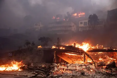 Getty Images
Beachfront and hillside homes in Malibu, CA burn in the Palisades Fire on Wednesday, January 8, 2025
Two fires have been contained:
Woodley fire: Small fire reported in local parkland. Burnt area: 30 acres.
Olivas fire: Small fire first reported in Ventura county about 50 miles (80km) east of Los Angeles. Burnt area: 11 acres.
How did the Palisades fire spread?
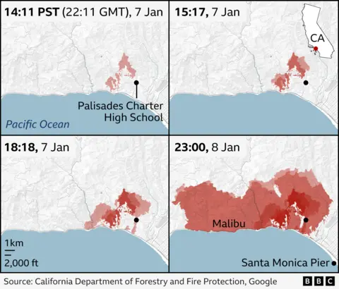
The map above shows how rapidly the Palisades fire spread, intensifying in a matter of hours. At just after 14:00 on Tuesday it covered 772 acres and within four hours it had approximately tripled in size.
It now covers more than 17,000 acres and thousands of people have been forced to evacuate the area, as more than 1,400 firefighters try to tackle the blaze.
The Eaton fire has also grown rapidly from about 1,000 acres on Tuesday to more than 10,000 acres, forcing thousands more people to flee.
Largest fires have burnt thousands of buildings
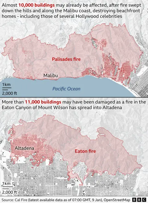
As the maps below show, about 20,000 buildings may have been damaged or destroyed already - and many more could be at risk depending on how the fires spread.
How does the Palisades fire compare in size with New York and London?
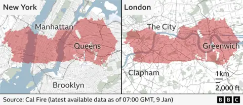
To give an idea of the size of the Palisades fire, we have superimposed it on to maps of New York and London.
As you can see by 23:00 PST, 8 January, (07:00 GMT, 9 January), it was comparable in size with an area stretching from Clapham to Greenwich in the UK's capital, or with large areas of lower Manhattan and Queens.
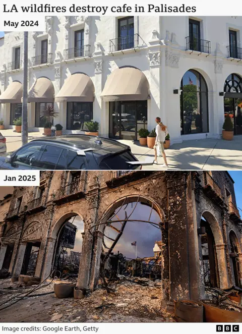
Effects of the Eaton fire
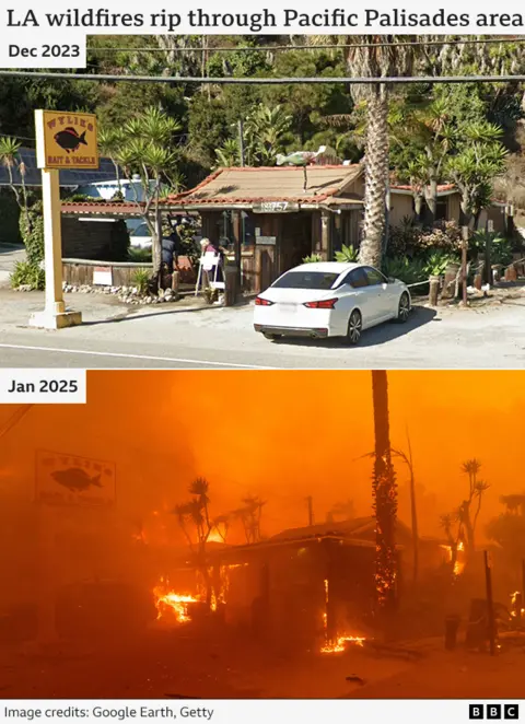
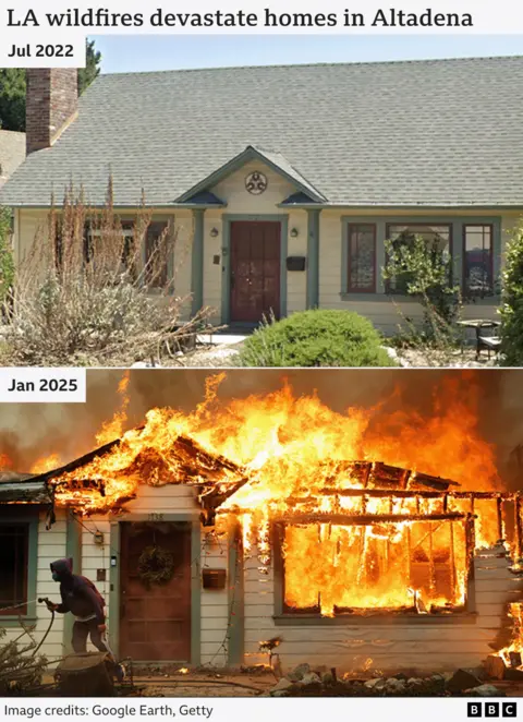
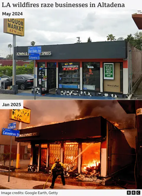
The Palisades fire is not the only one to have a devastating effect on neighbourhoods of Los Angeles.
Theses images show the extent of the destruction caused by the Eaton fire in the neighbourhood of Altadena.
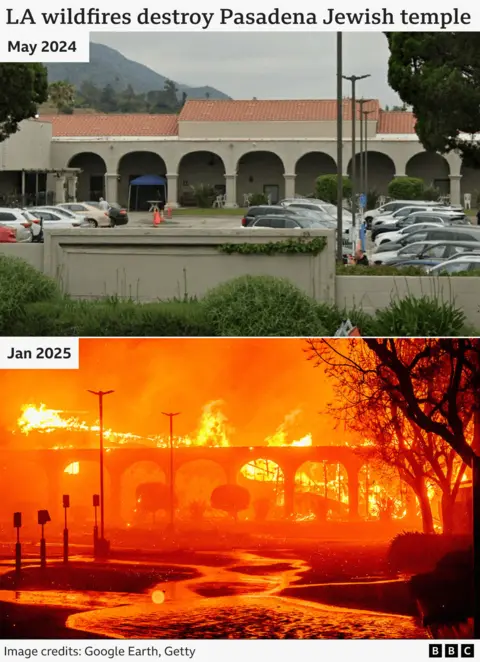
The Jewish Temple in Pasadena was destroyed by the Eaton fire. The Centre's website says it has been in use since 1941 and has a congregation of more than 400 families.
